


Pawnee Township Voting District, Smith County, Kansas
About
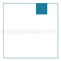
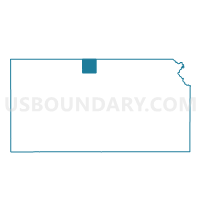
Outline

Summary
| Unique Area Identifier | 587424 |
| Name | Pawnee Township Voting District |
| County | Smith County |
| State | Kansas |
| Area (square miles) | 35.77 |
| Land Area (square miles) | 35.57 |
| Water Area (square miles) | 0.19 |
| % of Land Area | 99.46 |
| % of Water Area | 0.54 |
| Latitude of the Internal Point | 39.95181790 |
| Longtitude of the Internal Point | -98.66361240 |
Maps

Graphs
Select a template below for downloading or customizing gragh for Pawnee Township Voting District, Smith County, Kansas


Neighbors
Neighoring Voting District (by Name) Neighboring Voting District on the Map
- Beaver Township Voting District, Smith County, KS
- Cora Township Voting District, Smith County, KS
- East Franklin Precinct, Franklin County, NE
- Logan Township Voting District, Smith County, KS
- Red Cloud 2nd Precinct, Webster County, NE
- Washington Township Voting District, Smith County, KS
- White Rock Township Voting District, Smith County, KS
Top 10 Neighboring County Subdivision (by Population) Neighboring County Subdivision on the Map
- District 3, Webster County, NE (725)
- Washington township, Franklin County, NE (123)
- Washington township, Smith County, KS (57)
- Beaver township, Smith County, KS (48)
- White Rock township, Smith County, KS (43)
- Logan township, Smith County, KS (37)
- Cora township, Smith County, KS (26)
- Pawnee township, Smith County, KS (24)
Top 10 Neighboring Unified School District (by Population) Neighboring Unified School District on the Map
- Smith Center Unified School District 237, KS (2,910)
- Franklin Public Schools, NE (1,873)
- Red Cloud Community Schools, NE (1,542)
Top 10 Neighboring State Legislative District Lower Chamber (by Population) Neighboring State Legislative District Lower Chamber on the Map
Top 10 Neighboring State Legislative District Upper Chamber (by Population) Neighboring State Legislative District Upper Chamber on the Map
Top 10 Neighboring 111th Congressional District (by Population) Neighboring 111th Congressional District on the Map
Top 10 Neighboring Census Tract (by Population) Neighboring Census Tract on the Map
- Census Tract 4759, Smith County, KS (2,051)
- Census Tract 9651, Webster County, NE (1,838)
- Census Tract 9647, Franklin County, NE (1,803)